


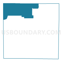
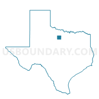
Voting District 0023, Young County, Texas
About
Outline

Summary
| Unique Area Identifier | 678373 |
| Name | Voting District 0023 |
| County | Young County |
| State | Texas |
| Area (square miles) | 126.87 |
| Land Area (square miles) | 125.86 |
| Water Area (square miles) | 1.01 |
| % of Land Area | 99.20 |
| % of Water Area | 0.80 |
| Latitude of the Internal Point | 33.34822130 |
| Longtitude of the Internal Point | -98.80620090 |
Maps

Graphs
Select a template below for downloading or customizing gragh for Voting District 0023, Young County, Texas


Neighbors
Neighoring Voting District (by Name) Neighboring Voting District on the Map
- Voting District 0003, Baylor County, TX
- Voting District 0005, Archer County, TX
- Voting District 0007, Archer County, TX
- Voting District 0010, Young County, TX
- Voting District 0011, Archer County, TX
- Voting District 0020, Young County, TX
- Voting District 4005, Throckmorton County, TX
Top 10 Neighboring County Subdivision (by Population) Neighboring County Subdivision on the Map
- Holliday CCD, Archer County, TX (5,440)
- Olney CCD, Young County, TX (3,841)
- Archer City CCD, Archer County, TX (3,614)
- Throckmorton CCD, Throckmorton County, TX (1,175)
- Newcastle CCD, Young County, TX (987)
- Jean-Loving CCD, Young County, TX (652)
- Seymour Rural CCD, Baylor County, TX (627)
Top 10 Neighboring Place (by Population) Neighboring Place on the Map
Top 10 Neighboring Unified School District (by Population) Neighboring Unified School District on the Map
- Graham Independent School District, TX (13,559)
- Olney Independent School District, TX (4,260)
- Throckmorton Independent School District, TX (1,165)
- Newcastle Independent School District, TX (1,084)
Top 10 Neighboring State Legislative District Lower Chamber (by Population) Neighboring State Legislative District Lower Chamber on the Map
Top 10 Neighboring State Legislative District Upper Chamber (by Population) Neighboring State Legislative District Upper Chamber on the Map
Top 10 Neighboring 111th Congressional District (by Population) Neighboring 111th Congressional District on the Map
Top 10 Neighboring Census Tract (by Population) Neighboring Census Tract on the Map
- Census Tract 9504, Young County, TX (5,720)
- Census Tract 9502, Young County, TX (4,493)
- Census Tract 9503, Baylor County, TX (3,726)
- Census Tract 203, Archer County, TX (3,614)
- Census Tract 202, Archer County, TX (2,780)
- Census Tract 9503, Throckmorton County, TX (1,641)